Peter’s Paragliding Nomadness
Paragliding Chamonix
October 3, 2007

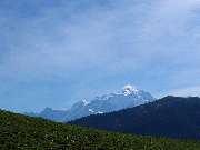
Mont Blanc is 4,807 meters (15,771 feet) high, the highest peak in Western Europe, and can be seen from miles away. As I approached through the Col des Aravis, it beckoned in the distance with a bright lenticular cloud hovering over the peak.
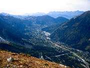
I was on my way to Chamonix. A valley at the base of Mont Blanc with a telepherique to the Aiguille du Midi, only 3,891 meters high.
The forecast is for rain the next few days. If I am going to fly, it will have to be this afternoon.
As I arrive in Chamonix, I see two paragliders doing acro over the town. I follow them to the Bois du Bouchet landing field, right in the middle of town.
They happily tell me where to get the telepherique (cable car) to launch. Unfortunately, the wind is from the south, so there is no flying from the upper launch today, but there is a launch at the middle stop, just get off there.
A half hour later, I have joined some tourists in the massive cable car, along with a half dozen paraglider pilots on the way to launch. This is travelling in style. No crowding 6 wings and pilots into an SUV and trundling off over barely passable rutted roads. Just get on at the bottom and get off at the top.
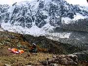
The main launch is closed for some reason, so the launches are from a temporary wild launch spot in a niche in the rocks. I've seen worse. The snow level is barely a few meters higher up.
The front is moving in and the morning sunshine has given way to cloudy skies. No thermals to climb today. But from this height, the extended sledder over the town of Chamonix will last 22 minutes and how often do you get to hang out over a ski village with views of the Chamonix Valley, snow-capped Mont Blanc and a glacier?

Launching at Plan de l'Aiguille, Chamonix.
There are more pictures in the Photo Album